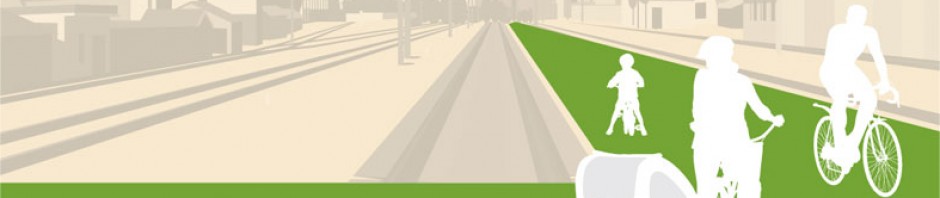

Extending from North Leichhardt to the Anzac Bridge, the City West Cycle Link would run entirely within the decommissioned Lilyfield rail corridor to provide a flat, quiet, green and wholly off-road cycling connection to the city’s separated (“green lanes”) cycleway network. The City West Cycle Link would address the missing link to the city for feeder cycling routes such as the (soon to be completed) GreenWay, Bay Run, and further afield, the Cooks River Cycle Path, and in doing so, fully unlock the value of those paths.
Section One – The Western Portal
Presently… 
people who ride towards the city from the inner west ultimately arrive to Lilyfield Road at Hawthorne Canal (pictured) at which point they are faced with a steep climb up to James Street (2). This climb is insurmountable for inexperienced or less competent cyclists. There isn’t an alternative route of similar convenience and directness to Lilyfield Road.
Cyclists using the soon-to-be-completed GreenWay* cycleway (3) will also be confronted with this hill.
* Currently under construction, The GreenWay shared path will provide a largely flat, off-road north-south cycling route between the Cooks River Path at Dulwich Hill and the Bay Run at Iron Cove.
Further, for cyclists intending to join Lilyfield Rd from the south via Darley Rd (4), the intersection with the City West Link road also presents the additional barriers of sharp gradient increases on Darley Rd and James St, insufficient road space for safe passage and restrictive signal green time to cross the six lanes plus slip lanes of the City West Link road.

The City West Cycle Link…
will remove all of these barriers by means of a cycleway via the Rozelle rail corridor. The City West Cycle Link would commence at Charles St and extend east on the northern side of the
Leichhardt North light rail stop. The Charles St (5) portal would serve as the entry point to the City West Cycle Link for cyclists approaching from:
• Lilyfield and Rozelle,
• Inner West regions such as Five Dock, Abbotsford and Concord (6),
• areas serviced by the GreenWay (7),
• and from Leichhardt (8),
without the need for them to negotiate steep gradients or heavily-trafficked roads.
Section Two – Lilyfield Cutting

The presumed barrier to the provision of a cycleway through the Rozelle rail corridor has always related to the misconception that there isn’t room sufficient for both a twin-tracked rail line and a cycleway within the Lilyfield section of the corridor.
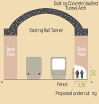
 The City West Cycle Link cycleway would be made possible by undercutting the northern face of the Lilyfield rail tunnel (between Darley Rd and Derbyshire Rd – Sectional View A-A) and rail cutting (between Derbyshire Rd to a point midway between Balmain Rd and Catherine St – Sectional View B-B).
The undercutting would be simply excavated and left as a rough-hewn rock face finish. Excavation would be means of heavy machinery which would require the full width of the rail cutting.
The City West Cycle Link would sit within the tunnel and cutting without restricting the ability to provide the twin track rail formation proposed for the Inner West Light Rail service.
This section of the cycleway would:
• Provide a separated, at-grade, cycleway running within the existing rail tunnel/cutting;
• Utilise the northern side of the rail cutting and by undercutting into the rock face provide a 650m long cycleway 3.5m wide by 3.0m high; Section two
• Be separated from the rail formation by fencing to ensure the safety of cyclists and light rail passengers alike;
• Closely integrate with the proposed Leichhardt North light rail stop.
The benefits of this section of the cycleway include:
• Allowing cyclists to bypass the very steep climb up Lilyfield Road;
• Removing cyclists from “car door” lanes and high speed traffic;
• Not interfering with the alignment or design of Inner West Light Rail;
• Integrate with the proposed Leichhardt North Light Rail station
Due to the potential for disruption to the Inner West Light Rail service, it would be impractical to undertake construction of the cycleway tunnel once the Light Rail’s power, cabling and signalling infrastructure have been installed. Consequently, the construction of the City West Cycle Link would need to be completed prior to the commissioning of the light rail service.
Section Three – Derbyshire Road to Catherine Street

Once clear of the Balmain Road cutting, the cycleway will continue east under the Catherine St overpass to the northerrn side of the Lilyfield stop. A connection from the cycleway to the light rail stop would be provided. From there, cyclists would have an uninterrupted, essentially flat run all the way to the Anzac Bridge via the Rozelle rail corridor.
 The depth of the Balmain Road cutting (shown) indicates the rise that cyclists presently endure when commuting via Lilyfield Rd. The northern side of the cutting, into which the cycleway will be undercut and fenced off, appears on the right hand side of the photograph.
Section Four – Catherine Street to Gordon Street
The City West Cycle Link will continue east from the Catherine Street underpass and Lilyfield light rail stop as a flat cycleway all the way to the Anzac Bridge Shared User Path. Although not costed as part of this proposal, an at-grade link to Gordon St is indicated which would allow for access to and from Lilyfield.

The alignment of the cycleway shown within the Rozelle rail lands is merely indicative. Its final alignment would depend on associated land use planning decisions such as the Bays Precinct planning process being undertaken by local councils and the Sydney Harbour Foreshore Authority.
Although this proposal is based on the concept of provision of only a cycleway (rather than a shared user path which may be used also by pedestrians), it should also be noted that there is sufficient space within the open sections of the rail corridor east of the Lilyfield rail stop to accommodate cyclists and pedestrians on separated paths, in a style similar to the Bay Run shared user path.
Section Five – Gordon Street to the Anzac Bridge Cycleway
The final section of the City West Cycle Link will pass under Victoria Road via the existing and already sufficiently- wide underpass and connect to the existing Anzac Bridge Shared User Path. From there, cyclists could continue their journey over the Anzac Bridge to the city or alternatively, use the City West Link Road overpass to access Glebe or Bicentennial Park.
It should be noted that the cycleway alignments shown are indicative only and not intended as a recommended engineering treatment. The design of the City West Cycle Link’s junction with the Anzac Bridge shared user path would seek to:
• Uphold the safety of cyclists and pedestrians alike;
• Permit cyclists on the Anzac Bridge path to maintain their speed going uphill in either direction;
• Minmise delays for cyclists entering or exiting the City West Cycle Link

The cycleway would bypass the narrow Victoria Road Overpass currently shared by pedestrians and bicycle riders.
 The path treatments to achieve these goals may include either a large triangular junction, small roundabout or very wide “slip” paths with adequate sight lines. This would be resolved at the detailed design stage in accordance with plans for adjacent land uses and the Government’s consideration of extending the City West Cycle Link north over the Glebe Island Bridge.
Great work guys, had thought about how to do the cutting, makes sense. Firing up my writing brain now to get hold of minister. cheers gw
Great stuff Grant. Good on you for taking action.
Please send your letter to some/all of the contacts listed on our “Take Action” page, but particularly:
State Govt
office@berejiklian.minister.nsw.gov.au [Transport Minister]
office@gay.minister.nsw.gov.au [Roads Minister]
office@premier.nsw.gov.au [Premier]
balmain@parliament.nsw.gov.au [Member for Balmain]
sydney@parliament.nsw.gov.au [Member for Sydney]
…and Councillors in your Local Government Area
Thanks for your support
David
Convenor
CWCL Action Group
I was wondering if the plan is to make it a SUP or a Cycle only path?
If it is a SUP then the cutting would have to be at least 4metres wide and separate the pedestrians from the bikes.
However a SUP would appeal to more of the community, such as the Greenway project.
Good work
Paul
Hi Paul
The proposal is pitched as a cycleway only, and not a shared user path (SUP) because the support of Councils is contingent on it being so and because of the restricted tunnel access. However, we don’t seek to exclude the possibility of some or all of the corridor (which is very wide at the city-end) providing also for pedestrians. To do so, however, would require more infrastructure such as ramps and bridges (which of course would also benefit riders) and therefore increase the cost of the proposal. These are decisions that ultimately will be decided by the State Government. We are wanting to first secure access through the corridor by having it include at least a cycleway. We hope to be able to sit with the Transport Minister one day to better align our concept with her department’s ideas. Hence, we are keen that the public write to the Minister expressing its desire for the CWCL (see the “Take Action” page).
Thanks for taking an interest.
I just noticed this interesting project on Copenhagenize. Food for thought for the City West Cycle Link.